Your Ultimate Adventure Altitude Companion
Get precise elevation readings, real-time weather updates, and reliable GPS tracking for all your outdoor adventures – even when you're completely offline.
Essential tools for every outdoor adventure
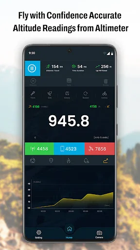
Precise Altitude Tracking
Know your exact elevation above sea level with advanced GPS technology that delivers accurate readings whether you're hiking mountains or exploring valleys.
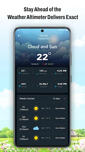
Real-Time Weather Updates
Stay safe with instant weather conditions including temperature, humidity, and wind speed – crucial information for planning your next move outdoors.
Works Completely Offline
Never lose access to essential altitude and location data, even in remote areas with no cell service – your safety companion that's always ready.
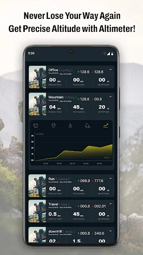
Adventure Photo Gallery
Capture and save your expedition moments directly in the app, creating a visual record of your adventures with precise location data attached.
About Altimeter GPS: Altitude Meter
Are you looking for an app that can measure your altitude accurately? Do you love hiking, skiing, mountain biking, or other outdoor activities? If yes Discover the ultimate adventure companion with GPS Altimeter, to elevate your outdoor experiences.
Altimeter GPS your ultimate companion for exploring the heights!
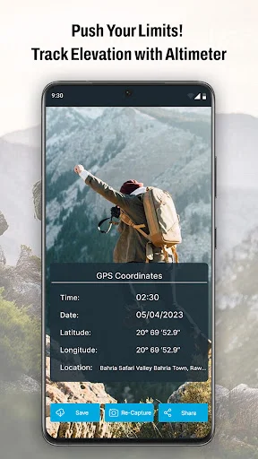
Altimeter My elevation is for checking your altitude level. GPS Altimeter tool shows the elevation level of the user while travelling or hiking, mountain biking ,and other outdoor activities. The GPS altitude app makes it easy to accurately measure your current location, elevation, and longitude and latitude at any time and from any place.
You may check altitude and current elevation at any moment and with great precision. With each step you take, the elevation displays your location. You can also check your latitude, longitude, and current location name and state with this altimeter altitude app. Share your location easily with your friends.
🧭Features of the GPS Altimeter - Altitude:🧭
- 🕛 Accurate Altimeter
- 🕛 Smart GPS Altimeter
- 🕛 Weather update
- 🕛 Current location
🕕 Accurate Altimeter:
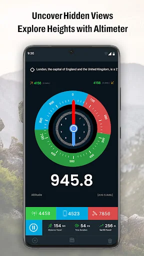
The Accurate Altimeter feature in our GPS Altimeter app tells you exactly how high you are above sea level. Whether you're climbing a mountain or flying in a plane, this feature uses advanced GPS to provide precise altitude readings. It give you accuarte information about your elevation, helping you stay informed and safe during your adventures.
🧭Smart GPS Altimeter:
It combines GPS data with other sensors in your device, to give you a more accurate and stable reading of your elevation. It's for hikers, climbers, and anyone who needs dependable altitude data on the go.
🧭Weather
The weather feature in the GPS Altimeter app gives you up-to-date weather information for your location. It shows you current conditions like temperature, humidity, and wind speed, so you can plan your activities better. This way, you can stay safe and be prepared for any weather changes while you're outdoors.
With Smart GPS Altimeteryou get more than just altitude readings. Plus, you can use the built-in camera feature to take photos of your adventures and save them directly in the app's gallery. This way, you can easily look back at your journey and share your experiences with friends.
See the precision in action
Trusted by outdoor enthusiasts worldwide
This GPS Altimeter app is highly functional and user-friendly. It provides accurate altitude and elevation measurements, perfect for outdoor activities like hiking and trekking. The interface is clean, and it’s easy to switch between different units. The app’s GPS coordinates feature is helpful for tracking locations, and it works well even offline. Highly recommended for anyone needing a reliable altimeter.
*5-Star Review* "Altimeter GPS excels in providing precise location and real-time weather updates, enhancing outdoor adventures. Its reliability, accuracy, and intuitive interface make it indispensable "Altimeter GPS impresses with: 1. Precise location tracking 2. Real-time weather forecasts 3. User-friendly design 4. Reliable performance Ideal for outdoor enthusiasts!"
The Altimeter GPS app is a must-have for outdoor enthusiasts, providing precise altitude readings and reliable navigation. Its user-friendly interface makes it easy to track your progress in real-time. With offline functionality, you can explore confidently even in remote areas.
Extremely accurate and user friendly this altimeter a has been a game changer for my hiking adventures Easy to navigate and reliable data Highly recommend.
A powerful app that calculates accurate altitude and elevation, showing geographic north, true altitude, and more. It's simple, stable, and secure ²
Best gps app for hiking and camping provides precise location elevation and weather data. Offline function is lifesaver
Download now and conquer new heights!
Start your journey with our growing community today